Local History & Galleries

Staverton through the years

Staverton is a village and parish in Northamptonshire, two miles west of Daventry on the A425, with around 200 homes and some 460 residents. There are Stavertons in Devon, Gloucestershire and Wiltshire too; this page is about ours. It gathers what is known of the village's past, the old maps of the parish, and the photographs that villagers have collected over the years.

Updated October 2026

On this page The village The church Maps 1801 to 2014 Galleries
The Village

A village on the heights

Staverton sits about 700 feet above sea level on one of the highest points of the Northamptonshire Heights, on an escarpment that looks west across the valley of the River Leam into Warwickshire. On a clear day the Malvern and Shropshire hills can be seen. Arbury Hill, a mile and a half to the south, is the highest point in Northamptonshire, and the River Nene rises nearby.

The name is usually taken to mean a "staked settlement": a place marked out by stakes, or where stakes were made. The village appears in the Domesday Book of 1086 as Stavertone, though people had been living and worshipping here long before that.

The fire of 1720

Until the early eighteenth century the heart of the village lay behind the church. In 1720 a fire swept through it, destroying haystacks, stables and grain stores along with 22 houses; the loss was put at around £3,000, a very large sum for a small parish.

A bequest from Elizabeth Darby paid for the village's own fire engine, a hand-pumped machine that came into service in 1767 and was kept in Staverton until recent times. It is now in a private collection of historic fire engines, and the parish council has looked into bringing it home. A plaque on a door opposite the village green records the gift.

Old houses and old roads

The manor house at the end of Manor Road may contain work from Anglo-Saxon times, and the village has many examples of local vernacular building. The Stables on Manor Road carries a datestone reading "R.R. 1684" above an unusual window.

Well Lane runs parallel to the A425 and was probably an earlier approach to the village: its deeply banked sides suggest an ancient right of way. As coaching traffic from the west increased, the route that became the Daventry to Warwick turnpike, today's A425, took over.

The railway and the tunnel

The western boundary of the parish follows the course of the Great Central Railway, the last main line built in Britain. The Great Central Railway Company laid it between 1894 and 1899 to run from Nottingham to London Marylebone, and it closed in the 1960s. While it was being built, a mission for the navvies was set up in a barn on the corner of Manor Road and Glebe Lane; the barn is now part of a private house.

Catesby Tunnel, in the west of the parish, was the longest tunnel on the Great Central's London line at 2,997 yards. It had been planned as a cutting, but the line ran through the estate of a wealthy landowner who would not have a railway in view, so a tunnel was dug instead. It has an unusual egg-shaped profile and eight ventilation shafts. The tunnel has since found a new life as a vehicle testing facility.

At a glance
County
Northamptonshire
Council
West Northamptonshire
Nearest town
Daventry, 2 miles east
Height
About 700 ft
Domesday Book
Stavertone, 1086
Great fire
1720
Fire engine
In service 1767
Residents
458 at the 2011 census
Postcode
NN11
St Mary the Virgin

The high church of the deanery

Staverton calls itself the "high church" of the Daventry Deanery's 25 parishes, and it is certainly the highest. A place of Christian worship has stood on this site for well over a thousand years. The churchyard is raised well above the surrounding ground, which suggests a burial ground was here for centuries before the present building, possibly from before 800 AD.

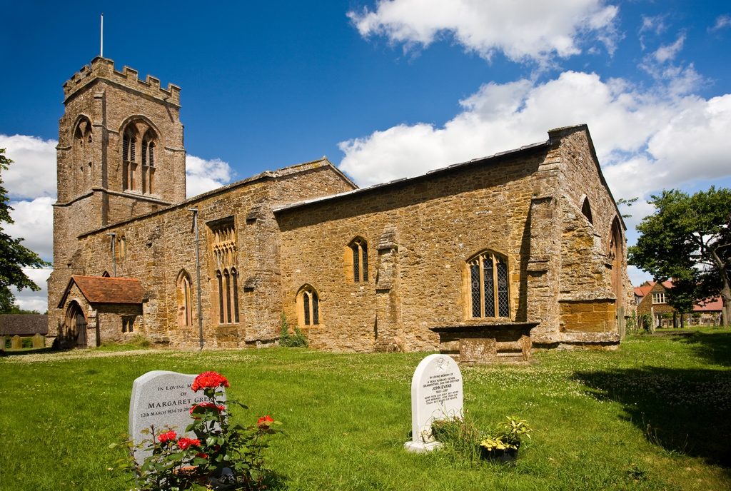
The list of vicars begins in 1220 and runs unbroken to the present day on a board inside the church. The building itself is mainly fourteenth century, with older work surviving, including a Norman lancet window in the north-west corner. The north porch, now the main entrance, is around 600 years old; the south porch is about a century older again, and its original door and roof timbers are still in place.

The tower holds a peal of six bells, cast in 1938 by John Taylor & Co of Loughborough. The restoration was set in motion by the Reverend E. S. Powell, vicar from 1933 to 1946, who rang bells himself, as did his wife. Bell-ringing is still very much alive: the village school has brought it into its music lessons, which has drawn television cameras and enquiries from as far away as Australia, and the ringers practise every Thursday evening from 7pm to 9pm. New ringers of any age are welcome.

The church is looked after by volunteers who mow the churchyard, clean the building and arrange the flowers on a weekly rota. Family Communion is held on the first Sunday of each month, and there is a quiet corner at the back where small children can play during services. Current service times are on the home page.

St Mary the Virgin church, Staverton
St Mary the Virgin. More photographs of the church are in the galleries below.
The church
Dedication
St Mary the Virgin
First recorded vicar
1220
Main building
14th century
Oldest window
Norman, north-west corner
Bells
Peal of six, 1938
Bell practice
Thursdays, 7pm to 9pm
Family Communion
First Sunday monthly
Photo Galleries

The village in pictures

Photographs collected by villagers and the parish council over the years. Click any picture to see it larger, then use the arrows to move through the set. If you have old photographs of Staverton to add, the parish clerk would be glad to hear from you.

The history on this page and the photographs in the galleries were gathered by Staverton Parish Council for its former website, and were brought across to stavertonvillage.com in October 2026 so that they stay available to the village. Corrections and additions are welcome: email henry@longhousecreations.co.uk.

Open full size